Company

Airbus defence and space

Empowering exploration and safeguarding the future, Airbus Defence and Space is committed to pioneering innovative solutions that transcend boundaries. Our mission is to elevate global security and advance the frontiers of space exploration through cutting-edge technology, unwavering dedication, and a steadfast commitment to excellence.

Airbus Defence and Space

About

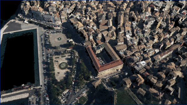
Airbus Defence and Space takes pride in its pioneering role as a premier provider of advanced solutions in the realm of Earth observation. Our commitment to excellence is exemplified through state-of-the-art technologies that redefine how we perceive and interact with our planet. With a laser focus on Earth observation, we empower industries, governments, and organizations with unparalleled insights into environmental dynamics, resource management, and global trends. Our cutting-edge satellite systems, sophisticated sensors, and data analytics capabilities form a comprehensive ecosystem designed to unravel the complexities of our changing world. From monitoring climate patterns and environmental shifts to optimizing agriculture and disaster response, our Earth observation solutions play a pivotal role in shaping sustainable practices and informed decision-making. At the heart of our mission is the conviction that a deeper understanding of our planet is the key to building a resilient and interconnected future. As we continue to push the boundaries of technological innovation, Airbus Defence and Space remains at the forefront of Earth observation, dedicated to providing solutions that transcend the ordinary and foster a more sustainable and prosperous world.

Agriculture; Climate; Atmosphere; Forests; Land Ecosystems; Land use

Certifcation
Website
Registration Number
Address
5. Rue des Satellites BP 14359 F-31030 Toulouse Cedex 4, France F-31030 Toulouse
Telephone
Fax
Email
Contact Name
Contact Position
Contact Telephone
Contact Email
Value chain
HQ location
Taufkirchen, Germany

Compare products

0 products added

Compare

Services comparison

services

Related Content

Starling
Forests
Explore Starling's satellite monitoring system, a cutting-edge solution in partnership with Earthworm Foundation. This collaboration enhances our ability to track and address deforestation in real-time, providing actionable insights to governments, organizations, and businesses. Starling, empowers you to actively contribute to forest preservation and sustainable land management.
Added
Added
Farmstar
Agriculture
Discover Farmstar's holistic precision agriculture solutions, seamlessly integrating satellite imagery, advanced sensors, and data analytics. Our products not only optimize crop management but also prioritize carbon-conscious farming. From monitoring carbon sequestration in soils to recommending eco-friendly practices, Farmstar leads the way in sustainable agriculture, helping more than 13 000 farmers yearly to cultivate responsibly and efficiently.
Added
Added
airbus product service test
product test
Added
Added
5D Multi-Purpose LIS (Land information System)
Agriculture, Infrastructure, Coastal, Floods, Forests, Inland Water, Land Ecosystems, Land use, Landslides, Sea-ice and icebergs, Snow & Ice, Topography, Urban Areas, Security, Assess Environmental impact of farming, Monitor crops, Assess Deforestation / Forest Degradation, Assess environmental impact of forestry, Assess and monitor water bodies   , Monitor land ecosystems and biodiversity, Monitor land cover and detect change , Baseline mapping , Map line of sight visibility (land surface), Asset infrastructure monitoring, Monitor coastal ecosystem, Monitor the coast line, Map and assess flooding, Detect and monitor wildfires, Forecast and assess landslides, Monitor sensitive risk areas, Forecasting epidemics and diseases, land administration, land use studies, monitoring of settlements, urban atlas, urban development, smart cities, rural areas, building inventory, building footprint, spatial planning, land cover, Solar energy, Construction, Forestry, Real-estate management, Transportation
The complexity of modern urban environments has led to the introduction of 3D Land Information Systems (LISs), which tend to replace traditional 2D LIS architectures for the purposes of urban planning and regeneration, land administration, real estate management and civil development. Both the need for 3D visualization of the geometry of buildings in various time instances through the years and the need for acquisition of 3D models in various levels of detail (LoDs), which not only fulfill the requirements of the various users but also they speed up the visualization process, are obvious. Thus, additional dimensions, that is, for time and scale, need to be supported by a modern LIS. This service introduces a 5D modelling pipeline that may be adopted by a multi-purpose LIS for the selective creation of 3D models of an urban area in various time instances and at various LoDs, enriched with cadastral and other spatial data. The methodology is based on automatic change detection algorithms for spatial-temporal analysis of the spatial changes that took place in subsequent time periods, using image orientation, dense image matching and structure from motion algorithms, the procedure requires photogrammetric stereo plotting, implements procedural modelling and relies on the availability of overlapping aerial and terrestrial imagery, ground control points and cadastral information.
Added
Added