Success story

Dynacrop - unlocking EO intelligence across the food value chain

Profile

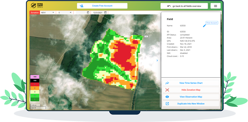
The food production sector must undergo a major change in order to sustain food production for a growing population and turn sustainable and carbon-neutral at the same time. Earth Observation is bringing tools that support the transition, but their adoption is slow due to the high complexity of the issue. DynaCrop is a white-label ecosystem enabling companies in the food value chain to use advanced information, statistics and intelligence based on Earth Observation. It provides ready-made crop monitoring, field statistics, application maps and soil moisture assessment on a global scale.

Proposal

DynaCrop pursues a synergy with companies already established in the food value chain and helps them to integrate EO-based information at scale. In this way, it minimizes resources needed for EO integration (money, time, human resources) and provides users with state-of-the-art service. Information is delivered through the value-added platform (API, white label web application, QGIS plugin) and users are receiving user-centric consulting and R&D cooperation as part of the cooperation.

Benefits

  • More sustainable food production corresponding to the increasing consumption needs
  • Support to turn carbon-neutral and therefore minimize the agricultural impact on the environment
  • Easily accessible information about crops, yields, soil moisture and other field data

Compare products

0 products added

Compare

Services comparison

services

Related Content

DynaCrop API
Crop monitoring Use different indices such as NDVI, MSAVI and EVI or biophysical parameters such as LAI or fAPAR to show current and historical dynamics of crop growth to your customers. Field scouting Let your users prioritize field visits based on satellite field scouting. We identify anomalies in the crop growth and allow farmers to visit problematic places sooner than they become a real threat. Zoning for variable applications Finetune fertilizing and seeding of your customers with the satellite prescription maps based on long term or short term analysis of the field performance. Apply dynamic variations in the strategies and indices used for each specific use case. Soil moisture Water availability is becoming a crucial limiting factor for crop yields. Our high resolution soil moisture maps allow farmers to recognise underlying patterns of water distribution in their fields. Soil organic carbon Soil organic carbon is an important indicator of soil health and it plays a key role in the soil management. Help your farmers to make more informed decisions based on the regular satellite monitoring.
Added
Added
Farmstar
Agriculture
Discover Farmstar's holistic precision agriculture solutions, seamlessly integrating satellite imagery, advanced sensors, and data analytics. Our products not only optimize crop management but also prioritize carbon-conscious farming. From monitoring carbon sequestration in soils to recommending eco-friendly practices, Farmstar leads the way in sustainable agriculture, helping more than 13 000 farmers yearly to cultivate responsibly and efficiently.
Added
Added