Success story

Firemaps.net supports management of UNESCO World heritage Site in West African Savanna

Detect and monitor wildfires; forest fire risk; damage

Profile

The UNESCO World heritage Site Comome National Park in Cote d'Ivoire, West Africa, is affected by large scale fires every year. Though fires are part of the savannah ecosystem of this large National Park, managers need to know more on extent, impacta, location and timing of the fires, as well as on related greenhouse gas emissions. This knowledge is needed to improve management of fires, plants and wildlife in the park.
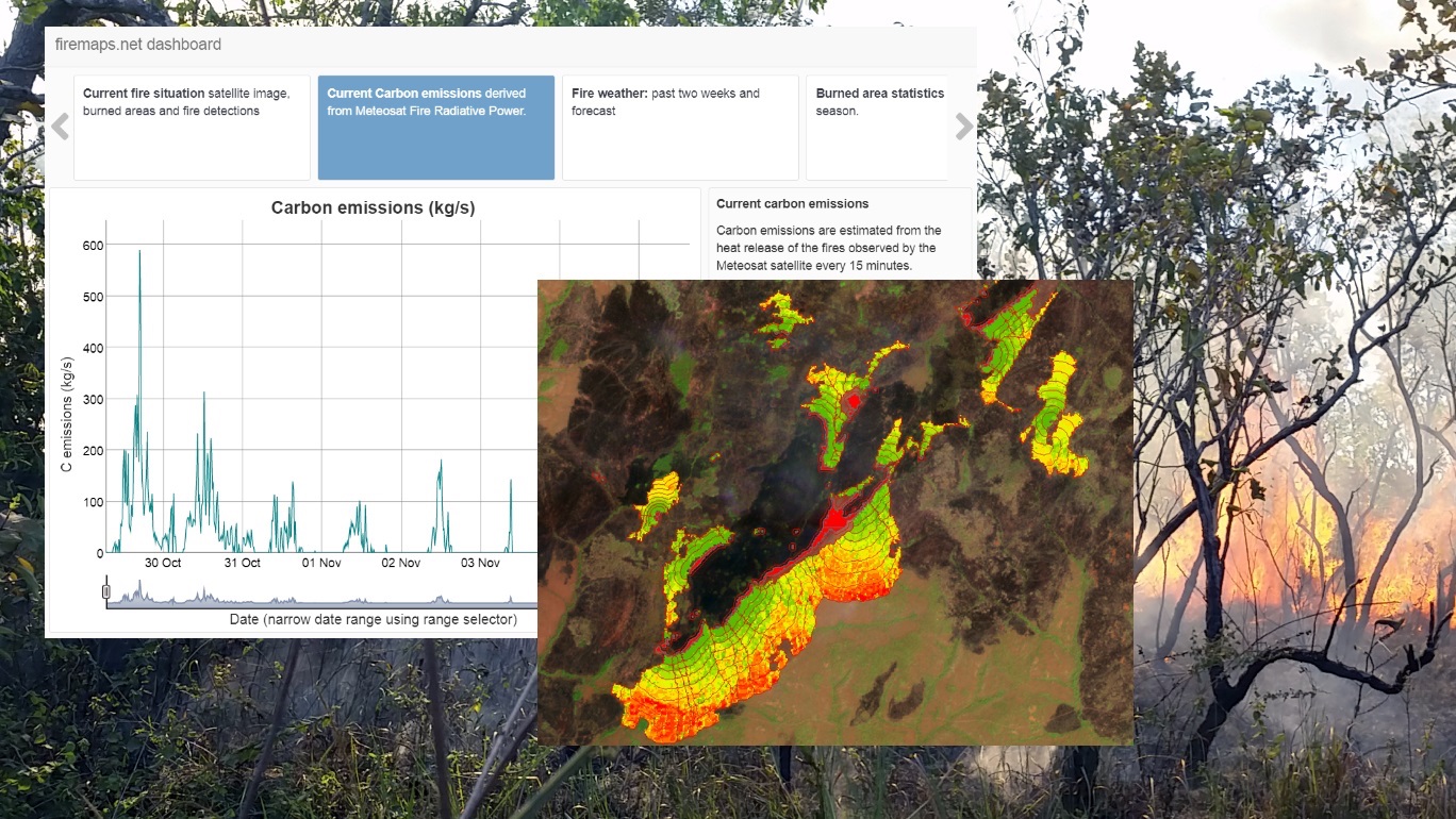
Proposal

To provide park managers with more insight into the fire dynamics of this large park and two adjacent agropastoral areas, ZEBRIS proposed the use of the platform firemaps..net to provide frequent and timely updates of burned areas and near real time monitoring of fires. To assess greenhouse gas emissions, measuring biomass burning and smoke release rates with infrared satellites was proposed. Fire risk and vulnerability were to be analysed using satellite data of past fire events, land cover information, weather data and fire behaviour models. Analysis and reporting-ready statistics were to be done largely automated in the processing environment provided by firemaps.net and served through a web GIS interface or as downloadable raster and vector data.

Benefits

  • Easy to use interface with no data processing skills required.
  • Ready to use statistics and charts.
  • Weekly updates of burned area.
  • Establishment of management objectives and the ability to track and report success

Compare products

0 products added

Compare

Services comparison

services

Related Content

Firemaps.net
Fires, burnt scars, damage, forest fire risk, fire extent, Climate, Atmosphere, Insurance & Finance
Firemaps.net provides monitoring of fires from satellites. We use mostly free Earth observation data form the Sentinel fleet and from NASA and Eumetsat, as well as weather and climate data from different providers. All data are automatically downloaded and processed in a cloud environment and delivered to the user through our firemaps.net platform. firemaps.net offers a web mapping and information interface, provides the products for download in the desired format and features a reporting ready fire statistics on user defined areas of interest. Using NASA MODIS and Landsat data we provide time series of over ten years for fire baseline assessment. Coupling Earth observation and weather data we provide online modelling of fire behaviour and fire risk. We currently develop a mobile app for offline use of firemaps.net.
Added
Added
5D Multi-Purpose LIS (Land information System)
Agriculture, Infrastructure, Coastal, Floods, Forests, Inland Water, Land Ecosystems, Land use, Landslides, Sea-ice and icebergs, Snow & Ice, Topography, Urban Areas, Security, Assess Environmental impact of farming, Monitor crops, Assess Deforestation / Forest Degradation, Assess environmental impact of forestry, Assess and monitor water bodies   , Monitor land ecosystems and biodiversity, Monitor land cover and detect change , Baseline mapping , Map line of sight visibility (land surface), Asset infrastructure monitoring, Monitor coastal ecosystem, Monitor the coast line, Map and assess flooding, Detect and monitor wildfires, Forecast and assess landslides, Monitor sensitive risk areas, Forecasting epidemics and diseases, land administration, land use studies, monitoring of settlements, urban atlas, urban development, smart cities, rural areas, building inventory, building footprint, spatial planning, land cover, Solar energy, Construction, Forestry, Real-estate management, Transportation
The complexity of modern urban environments has led to the introduction of 3D Land Information Systems (LISs), which tend to replace traditional 2D LIS architectures for the purposes of urban planning and regeneration, land administration, real estate management and civil development. Both the need for 3D visualization of the geometry of buildings in various time instances through the years and the need for acquisition of 3D models in various levels of detail (LoDs), which not only fulfill the requirements of the various users but also they speed up the visualization process, are obvious. Thus, additional dimensions, that is, for time and scale, need to be supported by a modern LIS. This service introduces a 5D modelling pipeline that may be adopted by a multi-purpose LIS for the selective creation of 3D models of an urban area in various time instances and at various LoDs, enriched with cadastral and other spatial data. The methodology is based on automatic change detection algorithms for spatial-temporal analysis of the spatial changes that took place in subsequent time periods, using image orientation, dense image matching and structure from motion algorithms, the procedure requires photogrammetric stereo plotting, implements procedural modelling and relies on the availability of overlapping aerial and terrestrial imagery, ground control points and cadastral information.
Added
Added