firemaps.net

firemaps.net provides monitoring of fires from satellites.

Fires; burnt scars; damage; forest fire risk; fire extent; Climate

Descripción del producto

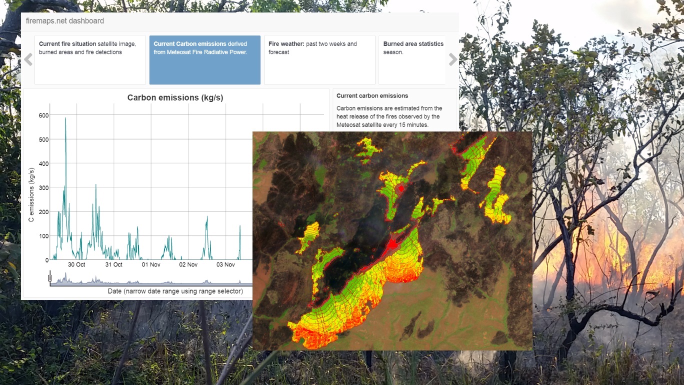
firemaps.net provides monitoring of fires from satellites. We use mostly free Earth observation data form the Sentinel fleet and from NASA and Eumetsat, as well as weather and climate data from different providers. All data are automatically downloaded and processed in a cloud environment and delivered to the user through our firemaps.net platform. firemaps.net offers a web mapping and information interface, provides the products for download in the desired format and features a reporting ready fire statistics on user defined areas of interest. Using NASA MODIS and Landsat data we provide time series of over ten years for fire baseline assessment. Coupling Earth observation and weather data we provide online modelling of fire behaviour and fire risk. We currently develop a mobile app for offline use of firemaps.net.

Idioma de servicio
English, Dutch
Lenguaje de metadatos
English
Acuerdo de nivel de servicio
Términos y condiciones
Licencia
Modo de entrega
Nivel comercial
Free
Estado del ciclo de vida del servicio
Escala
Localizador de servicios
Fecha de publicación
11 mar 2019

Beneficios

Benefits description

Modelo de pago
Precio a partir de

Especificación técnica

Resolución espacial entregable
Precisión de entrega vertical
Precisión de entrega horizontal.
Capas raster entregables
Capas vectoriales entregables
Precisión de entrega
Los formatos
  • OGC WMS, WCS, GeoTiff
Modelo de datos de entrega
Datos de entrega
Traductor de datos
Fecha de inicio de adquisición
Fecha de finalización de la adquisición
Estado

Lugar de servicio

Global (with a focus on Africa, South America and South East Asia)

Comparar productos

0 productos añadidos

Comparar

Comparación de servicios

servicios

contenido relacionado

Land and Land Cover Analysis
Agriculture, Infrastructure, Land Ecosystems, Land use, Farming, Insurance & Finance, Local and regional planners
With AutoMap, the handling of satellite images has never been easier! We simplify the production of maps based on earth observation data and handle the application of machine learning algorithms for land surface classifications by providing a solid data processing pipeline in a fully managed cloud infrastructure. Bring your own samples or use our default solution, while we take care of the thousands of images that fit your request, all the clouds in your area of interest and every aspect of process optimization and secure data storage. Don't worry about machine learning concepts, intelligent training data collection, hyperparameter optimization or informative feature spaces - That's our job as well! Seeing the world from above is now as demanding as ordering a pizza!
Adicional
Adicional
Land Cover Analysis
Floods, Inland Water, Land Ecosystems, Geology, Forests, Infrastructure, Land use, Urban Areas, Fires, Earthquakes, Construction, Emergency Services, Environmental, Pollution & Climate, Farming, Utilities (water, electricity, waste) , Oil and Gas, Minerals and Mining
LCA stands for Land Cover Analysis and is used to provide an up to date, digital overview of what covers the surface of our earth split out into 10 key land cover classes. The LCA is often the first step in many environmental monitoring or site selection processes.
Adicional
Adicional